
Skip map, read the guide ↓
Overview of Kathmandu Valley and its neighbouring districts

Drawing the valley map…

Select a place · Use + / − to zoom

75 mapped neighbourhoodsChoose a ward to explore its localities ↓Browse the neighbourhood index →

Kathmandu Metropolitan City has 32 wards. Select a labelled boundary on the map to open a ward guide and explore the neighbourhoods mapped within it. For places outside this boundary, use the wider Kathmandu District map.

Start with a familiar area

The city’s official ward directory identifies offices at Kalimati in Ward 13, Bhimsensthan in Ward 20, Baneshwor in Ward 10, Shantinagar in Ward 31 and Koteshwor in Ward 32.

These names help you find a starting point. Neighbourhoods and administrative wards are different kinds of places, so use the boundary map and the individual guide when checking a particular address.

The city’s heritage in context

Hanuman Dhoka Durbar Square, Swayambhu, Bauddhanath and Pashupati form part of UNESCO’s Kathmandu Valley World Heritage property. The property’s seven monument zones also include Patan, Bhaktapur and Changu Narayan; they are spread across the Valley.

For a smaller place name, browse the existing neighbourhood index or choose a ward above.
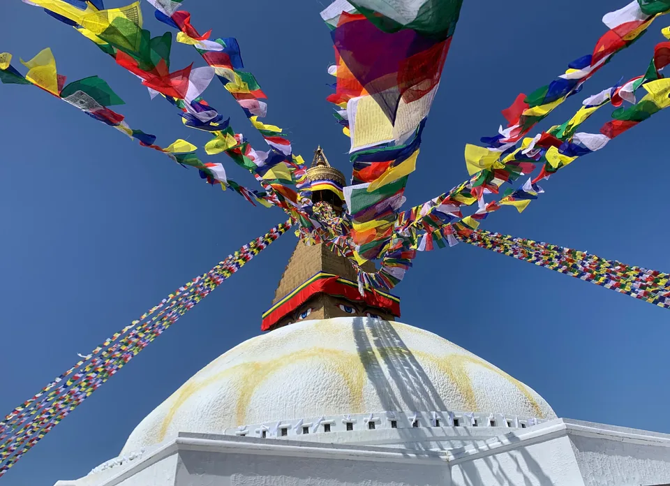
Colourful prayer flags stretch from the golden spire above Boudhanath’s white dome.
Prayer flags over Boudhanath Stupa, October 2025.Photo: Dudva / Wikimedia Commons · CC0. Resized and converted to WebP.

Wards in Kathmandu

Ward No. 1Naxal27.7131°N, 85.3248°EWard No. 2Lazimpat27.7209°N, 85.3251°EWard No. 3Maharajgunj27.7369°N, 85.3334°EWard No. 4Baluwatar27.7274°N, 85.3362°EWard No. 5Hadigaun & Bhatbhateni27.7162°N, 85.3345°EWard No. 6Boudha27.7225°N, 85.3608°EWard No. 7Mitrapark & Chabahil27.7171°N, 85.3464°EWard No. 8Jayabageshwori27.7095°N, 85.3544°EWard No. 9Gaushala & Battisputali27.6987°N, 85.3535°EWard No. 10Baneshwor27.6923°N, 85.3323°EWard No. 11Thapathali & Bagh Durbar27.6932°N, 85.3190°EWard No. 12Teku27.6965°N, 85.3045°EWard No. 13Kalimati27.7016°N, 85.2934°EWard No. 14Kalanki & Kuleshwor27.6907°N, 85.2884°EWard No. 15Dallu & Swayambhu27.7135°N, 85.2935°EWard No. 16Balaju27.7290°N, 85.3016°EWard No. 17Chhetrapati27.7124°N, 85.3072°EWard No. 18Naradevi27.7096°N, 85.3054°EWard No. 19Damaitol & Kankeshwori27.7066°N, 85.3043°EWard No. 20Bhimsensthan27.7034°N, 85.3036°EWard No. 21Jaisideval27.6986°N, 85.3072°EWard No. 22Tebahal27.7019°N, 85.3114°EWard No. 23Om Bahal27.7018°N, 85.3073°EWard No. 24Makhan Tole27.7057°N, 85.3082°EWard No. 25Masangalli27.7077°N, 85.3106°EWard No. 26Thamel & Lainchaur27.7230°N, 85.3142°EWard No. 27Asan & Mahaboudha27.7093°N, 85.3136°EWard No. 28Bagbazar & Kamaladi27.7043°N, 85.3185°EWard No. 29Anamnagar27.6986°N, 85.3281°EWard No. 30Gyaneshwor & Maitidevi27.7086°N, 85.3305°EWard No. 31Shantinagar27.6884°N, 85.3407°EWard No. 32Koteshwor27.6879°N, 85.3561°E